
Michael E. Wysession
Department of Earth and Planetary Sciences,
Washington University, St. Louis, Missouri 63130, USA
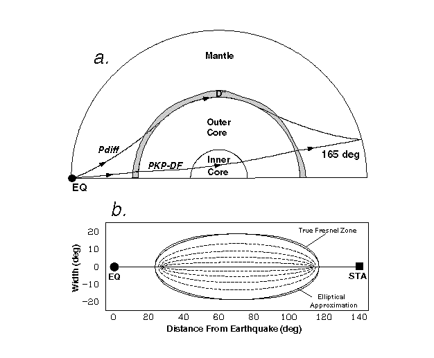
At the base of the Earth's mantle is a region, called D", whose complexity and geological significance has attracted much attention from the geophysical community1. The bottom few hundred kilometers of the mantle comprise a dynamically active thermal and chemical boundary layer between the silicate mantle and the liquid iron outer core2. Tomographic models of mantle P-velocities have their worst resolution in D" due to limited ray sampling3-5, but have hinted at large-scale lateral variations there. We present a map of the large-scale P-velocity variations within D" using a new technique which has its greatest resolution within D". We use the differential times of CMB-refracted PKP-DF arrivals and CMB-diffracted Pdiff arrivals. The Pdiff waves travel extensively within D", making them excellent probes for this layer, and the differential technique removes many effects from the ray paths outside of D"6. The significance of our map of the large-scale continent-sized structure at the CMB is that it can (1) serve as a benchmark for whole-mantle tomographic P-velocity models in this region, (2) be used as a source of comparison with existing S-velocity models 7,8, and (3) that similarities between our map and projections of paleosubducted lithosphere9 verify previous suggestions of a strong coupling between surface plate tectonics and the dynamics of the base of the mantle.
The modeling of differential seismic phases has revealed a high level of complexity in D", including discontinuous increases in velocity at the top of the region2,10-13, a very low-velocity layer just above the CMB14, and the presence of seismic anisotropy15-16. The structure of D" may be analogous to the crust and lithosphere at Earth's surface, and be the result of thermal, chemical, and mineralogical phase variations. However, the large-scale P-velocity variations at the CMB are still uncertain: existing tomographic P-velocity models correlate poorly with each other due to a "severe decrease in resolution" at the base of the mantle4, and studies of Pdiff profiles have limited regional coverage17-18. The use of Pdiff in a differential phase study (Fig. 1a) does not require a simultaneous inversion for the rest of the mantle, and gives a large-scale maps that is well-resolved over 3/4 of the globe. While whole-mantle tomographic models have the potential to map D" at smaller scales using P, PcP and PKP travel times, adequate resolution is currently limited to the CMB beneath eastern Asia and parts of the Pacific4. Shear velocity models have incorporated ScS and SKS data, and have attained a better resolution of the base of the mantle19-23. However, a full understanding of the geophysical processes operating in D" will require knowledge of both P and S velocities, so the new PKP-Pdiff map of D" P variations provides an independent image of the continent-size variations at the CMB that is complementary to existing S-velocity studies, and the differences between the two have significance as to the thermochemistry of the deep Earth. For instance, a decrease in the ratio of S-to-P velocities could mean an increase in the silicate/oxide ratio of D"17.
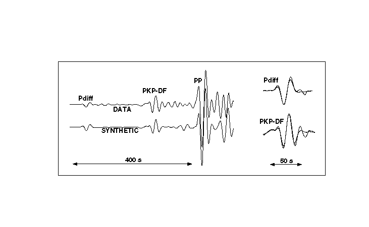
Pdiff has not been included in tomographic studies because of the rapid decay of high frequencies during core-diffraction. Pdiff is infrequently seen on short-period seismograms and therefore rarely reported to agencies such as the International Seismological Centre. The lack of high frequencies makes picking arrival times unreliable, and the resulting long-period waveform is too dissimilar from other phases in the seismogram to allow for a cross-correlated differential travel time. The technique we present uses a waveform comparison between the Pdiff and PKP-DF phases and their synthetic counterparts6 that are computed by using a reflectivity method24. The synthetic seismograms are computed with the PREM velocity structure25, and deviations in the timing of the Pdiff and PKP-DF arrivals represent anomalies from this reference earth model. The first parts of the pulses are aligned19, to avoid contamination from long source time functions, and the PKP-Pdiff travel time residuals are determined as
where travel time "corrections" are applied to help remove effects from ellipticity, inner core anisotropy26, the PKP mantle paths, and the Pdiff mantle paths outside of D" using ray-tracing through a 3D tomographic whole-mantle model5. The 543 residuals had a mean of -0.55 s, with a standard deviation of ± 1.87 s and a total range from -6.1 to +4.1 s. Variations in CMB topography cause changes to PKP-Pdiff of less then 0.02 s because they are both slower when the CMB is elevated. Errors in earthquake depths can add only small errors to ttres: at 140°, a 30 km error in hypocenter depth will change ttres by 0.17 s.
A problem with inverting the residuals for velocity structure along these ray-traces is that the Pdiff waves have enormous Fresnel zones, or effective sampling regions, at the CMB (Fig. 1b). This is due to the great epicentral distances involved (and resulting geometric spreading) and the large dominant periods of the Pdiff waveforms ( > 20 s). The PKP-Pdiff residuals are therefore converted into velocity anomalies, distributed across the 20 s Pdiff Fresnel zones, and then superimposed upon a grid of CMB nodes. The velocity perturbations at the nodes are obtained through a weighted, damped, least-squares inversion27 and shown in Fig. 2.
There is a total lateral variation of about 3% in the D" P-velocity for the long wavelengths at which we have resolution. This is vertically averaged over the lowermost mantle for the sampling regions of the long period Pdiff waves. The wavelengths we are able to resolve are on the order of 2000 km, based on the a priori use of the 20 s Pdiff Fresnel zones, which have a width on this scale, and the ability to recover a synthetic set of velocity anomalies (Fig. 3). We have good resolution of large features over about 3/4 of the globe, but not in the quadrant from 270° to 360° longitude. The 3% magnitude of variation is comparable with the results of tomographic P-velocity models (2-3%)3-5 and differential Pdiff studies17,18. Since the scaling between P and S velocities is likely to be at least 2.5 at the base of the mantle28, our 3% variations is also compatible with a recent long wavelength tomographic S-velocity model that includes SKS-Sdiff differential times (analogous to our PKP-Pdiff)8, but larger than for models that do not include the core-diffracted data5,7.
The striking similarity between the locations of fast seismic velocities in D" and the locations of paleosubduction zones9 reinforces the idea that D" may be the graveyard for subducted lithosphere. Much has been said about of the possibility of slabs penetrating into the lower mantle29, with some of the strongest support coming from high-resolution tomographic images21,30. Some of the positive seismic anomalies in D" from tomographic images have previously been given names like the "Pangea Trench" and "Tethys Trough" by Dziewonski and colleagues31, suggesting surface origins. Complementary to the idea of fast D" anomalies corresponding to cold rock brought from the upper mantle is the concept of D" as the origin of hotspot mantle plumes32. The PKP-Pdiff data suggest the locations of two large low velocity regions that correspond with the Equatorial Pacific Plume Group and Great African Plume features previously identified. The western part of the sub-Pacific low velocity region has been observed and examined by previous differential phase studies19,20,22, and is one region recently found to be underlain by a narrow zone of even slower velocities14. Our western African Plume extends westward beneath the northern Atlantic Ocean, though our resolution of this is poor. We also find a region of very slow velocities beneath the central Indian Ocean.
Fig. 2b shows the tomographic image of lowermost mantle P-velocities of Vasco and colleagues5, and the regions of reliable resolution correlate very well with the PKP-Pdiff image in Fig. 2a. It is significant, however, that variations exist between our map and the tomographic image of D" S-velocities by Su and colleagues7, shown in Fig. 2c. While there is generally very good agreement, such as the indication of the circum-Pacific fast velocities surrounding the sub-Pacific slow region, there are some noticeable differences. It may be that these models still lack the resolution to allow for accurate comparisons, but large variations in Poisson ratio exist in the surface crust as a result of textural and compositional variations33, and it may be the case that variations in the the temperature and chemistry of D" cause variations in the Poisson ratio of these regions17.
The fact that large-scale continent-sized P-velocity features do exist in D", and are not artifacts of inversion techniques, has other significant implications. The thermal or topographic anomalies that cause the velocity variations would be large enough to constrain patterns of outer core iron flow and therefore our geomagnetic field34. The existence of large continent-sized D" lateral variations suggests that the scales of convection at the top and bottom of the mantle may be similar, which provides a constraint for mantle convection models. Our new determination of D" P-velocities, with a strong resemblance to the locations of paleosubduction at the surface9, strengthens the existing argument for whole mantle mass transfer between the surface and CMB. Of course, the similarities could be coincidental or the result of thermal coupling between separate convective layers. And if whole mantle convection occurs episodically35 and we are between episodes, we might not be able to distinguish between the remnants of subducted slabs, the result of lower mantle convection, or part of a static chemical boundary layer.
Fig. 2 a, A map of the long-wavelength variation of P-velocities at the base of the mantle. The resolution of features is on the order of > 2000 km, based on the widths of the Pdiff CMB Fresnel zones and synthetic retrieval tests (Fig. 3). The velocities show a 3% lateral variation averaged over the bottom several hundred km of the mantle. The exact vertical sampling range of Pdiff up into the mantle along its CMB path varies as a function of frequency that varies as a function of CMB distance travelled. The labelled features come from the nomenclature of Dziewonski and colleagues31. There is a striking correlation between regions of fast D" velocities and the locations of Mesozoic paleotrenches9. Regions of fast P-velocity at the base of the mantle correspond to surface locations of the subduction of the Panthalassa, Pacific, Farallon and Tethys Sea floors since the Jurassic. Node velocities are obtained using a standard weighted, damped least-squares inversion27 of the PKP-Pdiff residuals distributed across the CMB Fresnel zones. The damping parameter is taken to be 1.2, which provides a good balance between weighing the least squares for the overdetermined part of the inversion and weighing the minimum length for the undetermined part. The map is formed by interpolating between the node values with a moving Gaussian cap. b, A map of D" P-velocity variations by Vasco and colleagues5, using a tomographic inversion of ISC P-arrival times. The regions beneath eastern Asian and the western Pacific Oceans are the only resolvable part of the lowermost mantle using this approach. Note that these regions correlate well with Fig. 2a, an encouraging fact given that the two maps are made with independent data. The P-wave data provide almost no coverage of the southern hemisphere, which is remedied by the PKP-Pdiff data. c, A map of D" S-velocity variations (at a depth of 2850 km) by Su and colleagues7, using a tomographic inversion of waveforms and absolute and differential travel times. This model provided the paleosubduction designations labelled in Fig. 2a 31. The circum-Pacific ring of fast D" velocities, surrounding the sub-Pacific slow velocity zone, is well-developed and is reproduced at longer wavelengths in the PKP-Pdiff map of Fig. 2a. While the agreement between this and Fig. 2a is quite strong, there are some disagreements: the circum-Pacific ring of fast velocities is unbroken beneath the northern Pacific Ocean for S-velocities, but not so for P-velocities; D" beneath the southern Pacific Ocean is fast for S-velocities but slow for P-velocities; and a region of fast S-velocities beneath the mid-East is found further to the south for P-velocities. While these differences may be the result of inadequate resolution, they may also indicate thermochemical variations which could affect S and P-velocity variations differently.
Fig. 3 Recovery of a synthetic model consisting of a checkerboard pattern of alternating velocity anomalies. a, Each anomaly is originally 45° in latitude by 90° in longitude, and has a value of *v = *1.5%. The 1D ray paths of the 543 data pairs were traced through this checkerboard pattern and the accrued travel time anomalies were then processed in a manner similar to that of the actual data. b, The pattern of recovered anomalies. Most of the CMB, from 0° to 270° longitude, has good resolution at the large scales resolved by our Pdiff paths. This is not the case from 270° to 360° longitude where the recovered anomalies are of reversed polarity, a result of smearing from the surrounding regions. In most cases we do a fairly good job of recovering the sharp transitions from fast to slow velocities. The recovered anomalies had a total range from -2.5% to 2.1%, though more than 90% of the regions were between -1.8 and 1.8%.
Acknowledgments. I thank E. Okal and T. Lay for helpful discussions, and C. Bina and T. Clarke for assistance with reflectivity codes. I thank Ed Garnero and an anonymous reviewer for insightful comments and suggestions.